Smarter Property Management with GeoApps
Housing corporations manage more than buildings. They manage maintenance, sustainability targets, neighbourhood quality, resident impact and long-term investment decisions across an entire property portfolio. When information is spread across spreadsheets, asset systems and separate GIS files, it becomes harder to see where attention is needed first. GeoApps brings this information together on the map, giving teams a clearer view of the portfolio and helping them make better-informed decisions.
See your entire property portfolio in one overview
Managing hundreds or thousands of homes across different neighbourhoods quickly becomes complex. With GeoApps, property information can be linked directly to locations on the map. This makes it easier to see not only what is happening, but also where.
Housing corporations can combine information such as property type and ownership, rental status, planned maintenance, renovation projects, demolition or redevelopment plans, energy labels, sustainability measures and neighbourhood data. Instead of working through separate lists or systems, teams gain one spatial overview of the portfolio. This makes it easier to identify patterns, compare areas and quickly find the properties that require attention.
Prioritise maintenance with better spatial insight
Maintenance decisions are rarely isolated. The condition of a property may need to be considered alongside planned roadworks, neighbourhood improvements, sustainability projects or other investments in the same area.
GeoApps allows maintenance information to be visualised together with these other datasets. Teams can map properties with upcoming maintenance, recurring repair issues, planned renovations, building age and condition, and neighbourhood-level projects. This creates a clearer basis for prioritising maintenance and coordinating work across departments.
Turn sustainability targets into concrete action
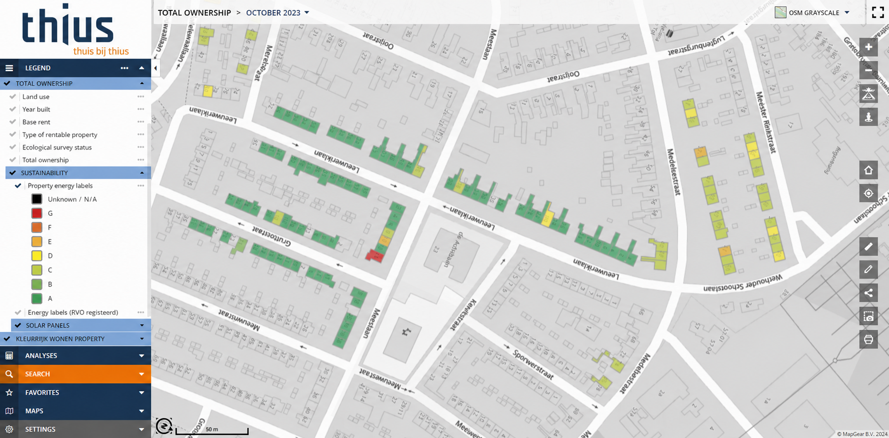
Sustainability targets become more useful when they can be translated into specific properties and neighbourhoods. GeoApps makes it possible to visualise the current sustainability status of the housing portfolio and compare it with planned measures.
Teams can see which homes have lower energy labels, where insulation measures have already been completed, which properties have solar panels and where further renovation is planned. By combining these datasets on the map, housing corporations can identify where the greatest opportunities remain and prioritise measures more effectively. Instead of looking only at portfolio-wide percentages, teams can see exactly where progress is being made and where additional action is needed.
Understand the impact on residents and neighbourhoods
A technically efficient maintenance or renovation plan can still create challenges when several projects affect the same neighbourhood at the same time. Spatial insight helps housing corporations understand this wider context.
By mapping planned projects, affected properties and neighbourhood information together, teams can assess how many residents may be affected, where projects overlap, which areas may experience repeated disruption and where communication should be prioritised. This makes property management more coordinated while also taking the impact on residents into account.
Give different teams the information they actually need
Not every employee needs access to the same information or functionality. Asset managers may need a portfolio-wide overview, sustainability teams may focus on energy performance, project managers may need to track planned works, while colleagues responsible for resident communication mainly need to understand which neighbourhoods will be affected.
GeoApps allows organisations to create applications tailored to these different workflows while working from the same underlying data. This reduces unnecessary complexity and helps each team work with the information most relevant to its role.
Move from scattered data to one spatial overview
Housing corporations often already have the necessary data. The challenge is bringing it together in a way that supports everyday decisions. GeoApps can connect property data with spatial information and make it available through clear map applications, dashboards and targeted workflows.
This reduces reliance on separate spreadsheets, makes information easier to find, improves coordination between teams and helps organisations identify priorities geographically. Existing property data becomes more useful because it can be viewed and analysed within the context of buildings, neighbourhoods and ongoing projects.
Make your property portfolio easier to manage
Effective property management starts with knowing what you own, what condition it is in, what is planned and where different challenges overlap. GeoApps brings these insights together geographically, helping housing corporations move from fragmented information to a clearer and more actionable view of their portfolio.
Want to see how GeoApps can support maintenance, sustainability and portfolio management across your housing stock?
Book a demo and discover how spatial insight can help your teams make better property decisions.