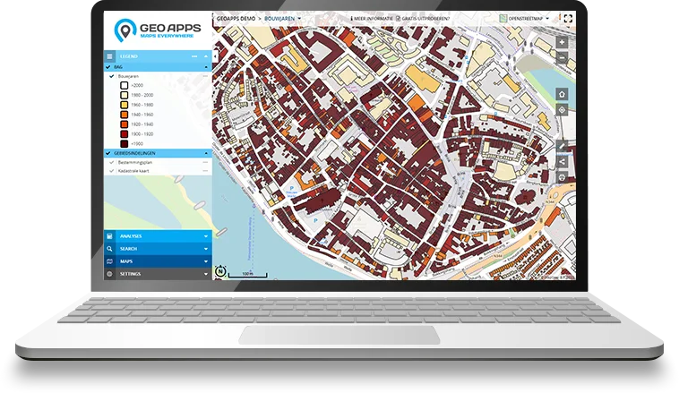
View map layers, analyze geodata and collaborate with colleagues. Everything in the browser - connect PDOK and your own data, without installing desktop GIS software.
From municipalities and provinces to international companies – GeoApps Viewer is the reliable choice for viewing and sharing spatial data.


A GIS viewer is a web application for viewing, querying and analyzing map layers and spatial data. Click the map for information, toggle layers on and off, and share insights with colleagues.
GeoApps Viewer is a GIS viewer for municipalities, provinces, water authorities, engineering firms and enterprises. More than viewing alone: user management, map editing, analysis, reporting and collaboration in one place. Unlike the free PDOK Viewer or desktop tools like QGIS, but without the complexity.
Supported standards include WMS, WMTS, WFS, GeoJSON, Shapefiles and GeoPackage. Connect PDOK, your own data sources and integrations such as Cyclomedia StreetSmart or 3D elevation models in one map.
Make geo-information accessible to everyone in your organization. From sharing interactive maps to analyzing spatial data: GeoApps Viewer brings users, data and processes together in one secure, web-based GIS environment.
No installation required. Open your GIS viewer in the browser on desktop, tablet or smartphone — always with the latest maps and data.
Connect WMS, WFS, GeoJSON, Shapefiles, GeoPackage and your own data sources in one clear interactive map.
Share maps, manage user rights, work together on projects and create reports from one central GIS environment so everyone works with the same up-to-date information.
Analyze your data with 3D views, object information, aerial imagery and Street View for faster insight and better decisions.
Get started with GeoApps Viewer in three simple steps and discover how easy it is to create powerful, interactive maps

Create your first online map viewer quickly and easily with GeoApps Viewer. Choose from standard color templates and style libraries, or customize with your own colors and icons. Set up user permissions to control who can view and edit your maps.

Take full control of your map data with GeoApps' comprehensive management tools. Benefit from enterprise-grade features like two-factor authentication and Active Directory integration. Perfect for larger organizations requiring secure, professional data handling.

Transform your data into actionable insights with GeoApps' powerful analysis tools. Create comprehensive reports for policy making, market research, or performance monitoring. Get instant results and export professional PDF reports in your corporate style.
Explore your spatial data from every angle with our cutting-edge visualization technologies.

Explore your spatial data in stunning three dimensions with realistic rendering, elevation models, and immersive navigation controls.
Learn more
View high-resolution aerial imagery from multiple angles for comprehensive site analysis and better understanding of your projects.
Learn more
Seamlessly navigate between map view and street-level imagery for ground-truth verification and detailed site inspection.
Learn more
Monitor your spatial data in real-time with automatic updates and live tracking. Stay informed of critical changes as they happen.
The best way to get to know GeoApps? Hear from organizations that use it every day. See how they speed up workflows, improve collaboration, and get more value from their geospatial data.

"GeoApps is a map viewer without fuss – super simple for end users and yet an extensive management environment for us as specialists."
Hugo van Beusekom
Project Manager Geo-data Management

"Calculations that used to take us a week are now done in minutes. This saves us enormous amounts of time and money."
Harry de Brauw
Energy Transition Advisor

"Documents are always up-to-date thanks to the integration with SharePoint. And the sales team decides for themselves who gets access and which documents are visible."
Jacco Wanders
GIS Advisor
"GeoApps is a map viewer without fuss – super simple for end users and yet an extensive management environment for us as specialists."
Hugo van Beusekom
Project Manager Geo-data Management
"Calculations that used to take us a week are now done in minutes. This saves us enormous amounts of time and money."
Harry de Brauw
Energy Transition Advisor
"Documents are always up-to-date thanks to the integration with SharePoint. And the sales team decides for themselves who gets access and which documents are visible."
Jacco Wanders
GIS Advisor

"The GeoApps map viewer gives us all the data to choose charging location locations; this way we work smarter, more efficiently and completely data-driven."
Charging Infrastructure Team
Qwello

"Thanks to GeoApps, we have all data and maps per district in one place. We can immediately visualize and share our urban challenges, making decision-making with colleagues and partners much faster and more transparent."
Amar Sjauw en Wa
Project Leader District Atlas
"The user-friendliness of the platform is excellent - our customers need hardly any instructions, the backend works pleasantly. Additionally, GeoApps works fast, securely and the team innovates continuously; that makes it a reliable partner for us."
Guido Palm
(former) Director
"The GeoApps map viewer gives us all the data to choose charging location locations; this way we work smarter, more efficiently and completely data-driven."
Charging Infrastructure Team
Qwello
"Thanks to GeoApps, we have all data and maps per district in one place. We can immediately visualize and share our urban challenges, making decision-making with colleagues and partners much faster and more transparent."
Amar Sjauw en Wa
Project Leader District Atlas
"The user-friendliness of the platform is excellent - our customers need hardly any instructions, the backend works pleasantly. Additionally, GeoApps works fast, securely and the team innovates continuously; that makes it a reliable partner for us."
Guido Palm
(former) Director
Join thousands of professionals who are already converting their data into valuable insights with GeoApps.


Answers to common questions about GIS viewers and GeoApps Viewer.