Data Becomes Valuable When People Can Understand It
Organizations often collect large amounts of geo-data, but making that information accessible to stakeholders can still be challenging.
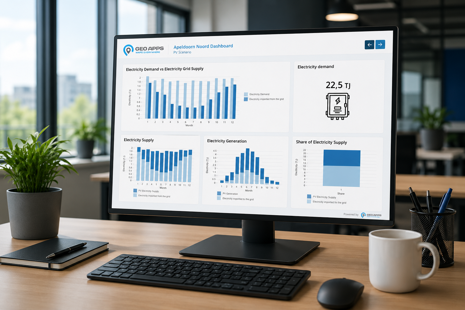
To address this, GeoApps V29 introduces Dashboards.
Dashboards allow organizations to combine maps, charts, text blocks, and key metrics into a single environment. Instead of reviewing separate datasets, users can view information in context and gain a clearer understanding of trends, developments, and performance.
This creates a central location where data and geography come together.
As a result, organizations can:
Monitor developments in real time
Track project performance
Communicate results more effectively
Support data-driven decision-making
Furthermore, visualizations update automatically, ensuring users always have access to the latest information.
Meanwhile, Managing Applications Becomes Simpler
As organizations create more maps, applications, and information products, maintaining structure becomes increasingly important.
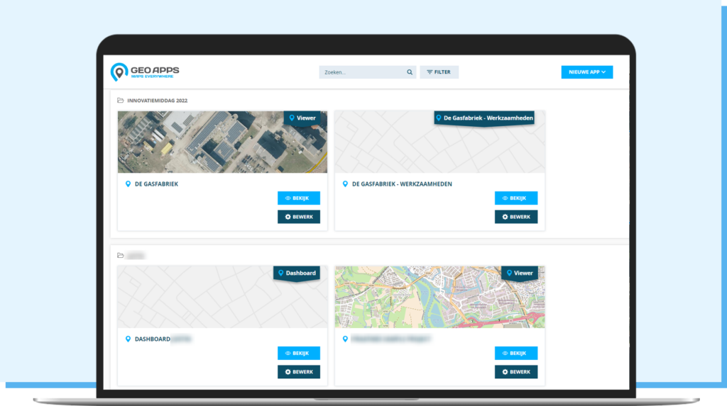
For that reason, GeoApps V29 introduces a redesigned Homepage.
The new Homepage provides users with a clearer overview of available maps and applications, making it easier to discover relevant information and navigate through environments.
At the same time, administrators gain greater control over how content is presented and organized.
Image Placement: New Homepage screenshot
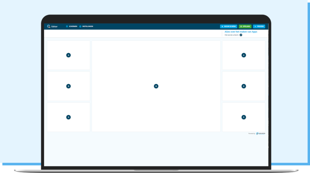
The release also introduces a powerful new Editor.
With the Editor, administrators can create and modify dashboards more efficiently without relying on complex management workflows. This allows organizations to respond faster to changing requirements and keep information up to date with less effort.
Benefits include:
Reduced management complexity
Faster implementation of updates
Greater flexibility for administrators
Improved user experience
Together, these improvements help organizations spend less time managing applications and more time using them.
In Addition, GeoApps Improves the Experience for End Users
Not every user works with geo-information every day. Therefore, usability remains a key focus within GeoApps.
GeoApps V29 introduces several enhancements that make maps easier to use and share.
For example, users can now export map views directly as JPG files. This makes it easier to include maps in presentations, reports, project documentation, and stakeholder communications.
Another addition is the new YouTube Block.
Organizations can embed videos directly into applications, creating opportunities to add project explanations, instructional videos, interviews, or timelapses alongside geographic information.
Furthermore, GeoApps expands its mobile capabilities.
Users can now draw directly on maps from mobile devices, making fieldwork, inspections, and participation projects more efficient and accessible.
These improvements help ensure geo-information is not only available but actively used throughout an organization.
GeoApps Continues to Support Innovation and Custom Development
Every organization has unique processes, goals, and information needs.
Therefore, GeoApps continues to provide opportunities for custom application development alongside its standard applications.
Through the Developer Portal, organizations and developers gain access to documentation, reference materials, and technical resources needed to build custom solutions tailored to their specific requirements.
This flexibility enables GeoApps to grow alongside evolving organizational needs and future innovations.
GeoApps V29 Helps Organizations Move Faster from Data to Decisions
The improvements introduced in GeoApps V29 share a common objective: making geo-data more accessible, actionable, and manageable.
By combining dashboards, improved management tools, enhanced mobile functionality, and expanded customization options, GeoApps helps organizations transform geographic information into meaningful insights.
As a result, maps become more than visualizations.
They become tools for communication, collaboration, and better decision-making.
Ready to discover how GeoApps can support your organization?
👉 Request a demo and experience how GeoApps turns geo-data into actionable insights.


