Skip to main contentSkip to navigation
ExploreJobsAbout usContact
Log in
MapGear Logo
JobsNewsAbout MapGear
Log inContact
MapGear, known through GeoAppsGeoApps
GeoApps Logo
Apps
Solutions
Platform
About us
Get advice
GeoApps Logo

GeoApps is the leading software platform for GIS applications and spatial data, enabling organizations to make data-driven decisions.

Solutions

  • Urban Planning
  • Infrastructure
  • Real Estate
  • Environment & Climate
  • Energy Transition
  • Safety & Risk

Products

  • GeoApps
  • Solutions
  • ESG-Maps
  • MapServices
  • TouchTable
  • Consultation

Apps

  • Viewer
  • Dashboard
  • Fieldwork
  • MapTour
  • MapTalk
  • Custom

For whom?

  • Municipalities
  • Provinces
  • Environmental Services
  • Engineering
  • Contractors
  • Safety Regions

Platform

  • Integrations
  • Documentation
  • GIS Lexicon
  • System Status
  • Changelog
  • Support
  • Subscriptions

Company

  • About Us
  • Careers
  • Contact
  • Partners
  • News & Blog
  • Events

Stay up-to-date

Subscribe to our newsletter to get the latest updates on our products and services. You can unsubscribe at any time.

Keep an eye on our socials too

Stay connected with us through our social media channels and get the latest updates on our products and services.

Quality & trust

MapGear is ISO 9001 and ISO 27001 certified and meets the highest quality and security standards for our products and services.

ISO 9001 Certificering
ISO 27001 Certificering
QGIS Membership 2026
© 2026 MapGear B.V. All rights reserved.
Terms & conditionsPrivacy PolicySustainability statement
GeoApps V28: Search Faster and Work Better in GIS. | GeoApps Blog
Featured image for GeoApps V28: Faster Search, Better Mobile Workflows and Direct Access to Property Information
View All Posts
📸 Featured
News

GeoApps V28: Faster Search, Better Mobile Workflows and Direct Access to Property Information

GeoApps V28 introduces expanded search capabilities, Kadaster KIK integration, mobile optimizations and improved user support. Discover how these updates help organizations work more efficiently with geospatial data.

May 18, 2022
GeoApps Team
3 min

Finding the right location, accessing property information and working efficiently in the field should not slow down GIS workflows.

GeoApps V28 introduces several improvements designed to make spatial information more accessible and easier to use. From expanded search capabilities and Kadaster integrations to mobile optimizations and improved communication tools, this release helps organizations work more efficiently with geospatial data.

Whether you manage municipal projects, infrastructure assets or environmental information, GeoApps V28 provides practical enhancements that improve daily operations.

Find Locations Faster with Expanded Search Capabilities

As GIS environments grow, finding the right location quickly becomes increasingly important.

GeoApps V28 expands search functionality beyond addresses alone. Users can now search for:

  • Addresses (BAG)

  • Parcels (Kadaster)

  • Roads (Nationaal Wegenbestand)

  • CBS neighbourhoods

Administrators can configure which datasets are available within their GeoApps environment, ensuring users always have access to the most relevant information.

Instead of manually navigating through large map environments, users can immediately locate the information they need and continue working more efficiently.

🖼️
Image not available
This image could not be loaded

Access Property Information Directly from the Map

Property ownership information often plays a critical role in planning, permitting and infrastructure projects.

With the Kadaster KIK integration, GeoApps users can retrieve ownership information directly from the map environment. This eliminates the need to switch between different systems and simplifies information gathering.

Organizations can use this functionality to:

  • Identify parcel ownership faster

  • Support planning and development projects

  • Reduce manual administrative work

  • Improve decision-making processes

By bringing property information directly into the GIS environment, users gain access to important context exactly when they need it.

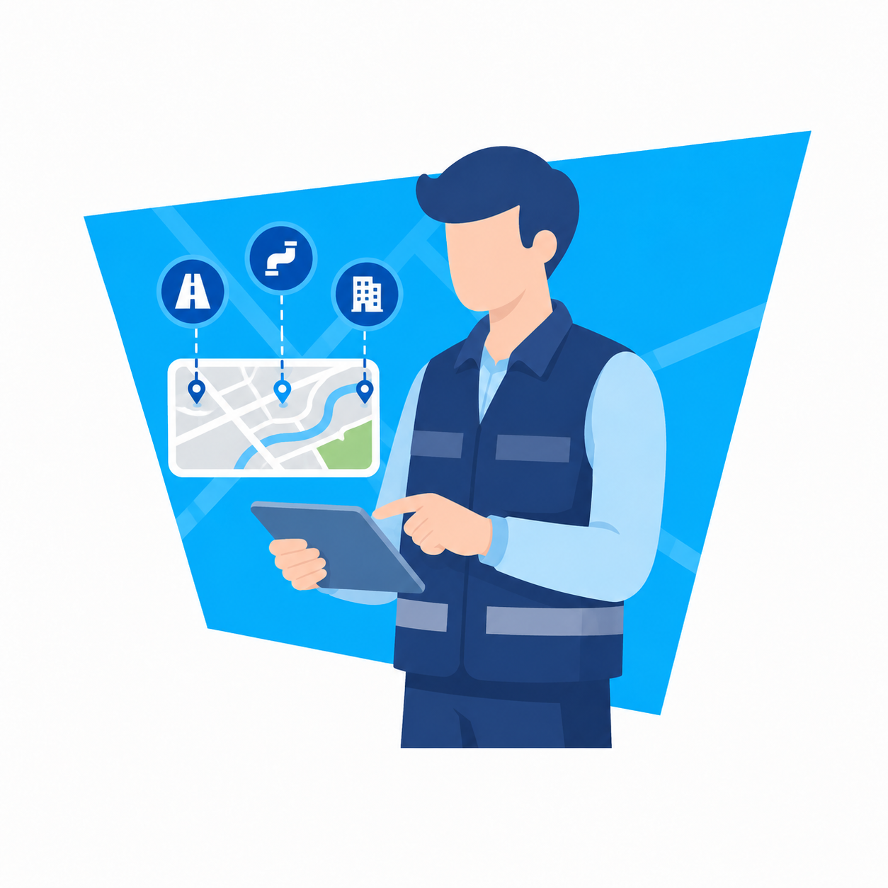
Improve Fieldwork with Mobile Optimizations

More organizations are relying on mobile devices to collect, validate and manage spatial information.

GeoApps V28 introduces several improvements that make working on smartphones and tablets easier and more efficient.

Users can now:

  • Edit objects directly from the map

  • Search for addresses on mobile devices

  • View object and street imagery

  • Benefit from improved MapTour performance

These improvements help field teams stay productive while maintaining access to critical information outside the office.

Stay Informed with Better Communication and Support

Managing a GIS platform involves more than maps and data.

Organizations also need clear communication regarding updates, improvements and support options.

GeoApps V28 introduces Beamer integration and an improved chat functionality, allowing users to:

  • Receive update notifications

  • Submit feature requests

  • Follow platform developments

  • Contact support directly

These additions create a more transparent user experience and help organizations stay connected with ongoing platform improvements.

Why These Improvements Matter

The most valuable platform improvements are often the ones that remove friction from everyday tasks.

Whether users are searching for locations, retrieving ownership information or collecting data in the field, GeoApps V28 helps streamline workflows and reduce unnecessary manual effort.

Organizations benefit from:

  • Faster access to relevant information

  • Reduced dependency on multiple systems

  • Improved mobile productivity

  • Better user experience

  • More efficient spatial workflows

As geospatial projects become increasingly data-driven, access to accurate and accessible information becomes essential for effective decision-making.

🖼️
Image not available
This image could not be loaded

GeoApps V28 focuses on making spatial information easier to find, access and manage.

Through expanded search capabilities, direct access to property information, improved mobile functionality and enhanced communication features, this release helps organizations work more efficiently with geospatial data.

The result is a platform that supports faster workflows, better collaboration and more informed decision-making.

Looking for a GIS platform that helps your organization work more efficiently?

GeoApps enables organizations to search, analyze and manage spatial information from a single environment.

Whether you work in government, infrastructure, environmental management or spatial planning, GeoApps provides the tools needed to turn geospatial data into actionable insights.

👉 Request a demo and discover how GeoApps can support your organization.

View All PostsGet a Demo

Related Posts

You might also like

GIS platforms in the Netherlands: what is the difference and where does GeoApps fit?

GIS platforms in the Netherlands: what is the difference and where does GeoApps fit?

A GIS platform is more than a map viewer. It supports organisation-wide spatial analysis, data-driven decision-making and communication using GIS and geospatial data.

January 14, 2026Read more
CBAM 2026: Why Location and Material Data Are Becoming Increasingly Important for CO₂ Reporting

CBAM 2026: Why Location and Material Data Are Becoming Increasingly Important for CO₂ Reporting

From January 1, 2026, the Carbon Border Adjustment Mechanism (CBAM) will be fully implemented within the European Union. For many organizations, this means stricter requirements for CO₂ transparency and reporting.

January 5, 2026Read more
From Rigid to Smart GIS: Why More Organizations Are Switching to QGIS + GeoApps

From Rigid to Smart GIS: Why More Organizations Are Switching to QGIS + GeoApps

Many GIS environments are still stuck in old structures. High license costs, slow updates, and limited collaboration slow down innovation. Discover how organizations are moving to an open, flexible, and future-ready WebGIS with QGIS + GeoApps.

October 17, 2025Read more
How to Create Clarity in a Region Full of Sustainable Initiatives

How to Create Clarity in a Region Full of Sustainable Initiatives

Municipalities and regions are dealing with countless sustainability initiatives. GeoApps helps bring data together and make it transparent so that policies and collaboration are better supported.

September 30, 2025Read more
How Online Maps Help Ecological Consultancy Flourish

How Online Maps Help Ecological Consultancy Flourish

Digital maps make ecological consultancy work more efficient and transparent. Discover how GeoApps supports organizations in nature research, public participation, and policy development.

September 30, 2025Read more
MapTalk, the ideal participatory tool to involve citizens in spatial projects

MapTalk, the ideal participatory tool to involve citizens in spatial projects

MapTalk makes citizen participation simple and effective. From home or at community events, residents can share feedback that helps shape better spatial projects and smarter decisions.

September 30, 2025Read more

Ready to Get Started?

Join thousands of users who are already using GeoApps to transform their spatial data workflows.

Get a Demo
GeoApps Viewer
Gasfabriek project
MapGear team office
Last Updated: June 19, 2026