ExploreJobsAbout usContact
Log in
MapGear Logo
JobsNewsAbout MapGear
Log inContact
MapGear, known through GeoAppsGeoApps

Cookie settings

We use cookies to improve your experience on our website. You can choose which types of cookies you accept. Learn more

GeoApps Logo
Apps
Solutions
Platform
About us
Get advice
GeoApps Logo

GeoApps is the leading software platform for GIS applications and spatial data, enabling organizations to make data-driven decisions.

Solutions

  • Urban Planning
  • Infrastructure
  • Real Estate
  • Environment & Climate
  • Energy Transition
  • Safety & Risk

Products

  • GeoApps
  • Solutions
  • Sustainability Map
  • MapServices
  • TouchTable
  • Consultation

Apps

  • Viewer
  • Dashboard
  • Fieldwork
  • MapTour
  • MapTalk
  • Custom

For whom?

  • Municipalities
  • Provinces
  • Environmental Services
  • Engineering
  • Contractors
  • Safety Regions

Platform

  • Integrations
  • Documentation
  • System Status
  • Changelog
  • Support
  • Subscriptions

Company

  • About Us
  • Careers
  • Contact
  • Partners
  • News & Blog
  • Events

Stay up-to-date

Subscribe to our newsletter to get the latest updates on our products and services. You can unsubscribe at any time.

Keep an eye on our socials too

Stay connected with us through our social media channels and get the latest updates on our products and services.

Quality & trust

MapGear is ISO 9001 and ISO 27001 certified and meets the highest quality and security standards for our products and services.

ISO 9001 Certificering
ISO 27001 Certificering
QGIS Membership 2026
© 2026 MapGear B.V. All rights reserved.
Terms & conditionsPrivacy PolicySustainability statement
Overview of Sustainable Initiatives in the Foodvalley Region | GeoApps Blog
How to Create Clarity in a Region Full of Sustainable Initiatives hero background

How to Create Clarity in a Region Full of Sustainable Initiatives

Municipalities and regions are dealing with countless sustainability initiatives. GeoApps helps bring data together and make it transparent so that policies and collaboration are better supported.

GeoApps Team• September 30, 2025News

Circular Feed, Gas-Free Districts, and Hydrogen Transport

With all the projects in the Foodvalley Region, it is easy to lose track. The area from Wageningen to Nijkerk is a leader in the food industry. But how do you know what is happening where? And how can entrepreneurs join ongoing initiatives?

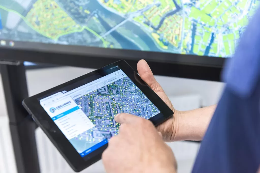
In June, Regio Foodvalley launched the Digital Project Map, built on the GeoApps platform. It is a valuable solution for a resilient and future-proof region.

Digital Hub

In the Foodvalley Region, governments, entrepreneurs, and educational institutions work together to create a region that is sustainable to live and work in. This collaboration in agrifood, nutrition, and health has been ongoing for more than ten years.

The digital map now brings together all active programs, research, and projects from the Strategic Agenda, which serves as the region’s guide for future impact.

“A central hub of all running projects in the region was missing,” says Dennis Gudden, Project Leader of the Entrepreneurs Desk, Regio Foodvalley.
“Many people want to contribute to a better living environment but do not know how. I often get questions about ongoing projects. Now everyone can explore the map and find what is relevant, from circular agriculture to healthy food.”

Direct Connections

The map helps initiatives and participants connect because what is unknown remains unseen.

“We want to make things as easy as possible for entrepreneurs,” says Dennis.
“That is why each project on the map includes a contact person and a phone number, so you can take action right away and speak directly with the project lead.”

For council members, residents, or students, the map provides a clear overview of what the Foodvalley Region is working on.

Within the map, you can find business support points and a complete overview of initiatives within Foodvalley, including:

  • Agriculture and vital rural areas

  • Nutrition for a healthy life

  • Energy transition

  • Human capital

  • Innovation, clustering, and circular economy

  • Physical planning conditions

  • Quality of living

  • And the programs of the Regio Deal

Education

Universities of Applied Sciences, ROCs, Utrecht University, and Wageningen University also use the map.

“Education plays a major role in training young people for the professions of the future,” says Dennis.
“We need well-trained people in the food industry and construction sectors. With the map, businesses and educators can find each other more easily and work together on solutions for the challenges of today and tomorrow.”

For example, students from WUR and CHE are involved in circular entrepreneurship research, the Entrepreneurs Desk, and projects such as Barneveld Tomorrow.

GeoApps Platform

All icons in the map match the structure of the Strategic Agenda.

“It is great that the software allows customization,” Dennis explains.
“The design of the map fits perfectly with Foodvalley’s visual identity and immediately engages the viewer.”

The map went live within three months and is now managed by Dennis and several colleagues.

“User-friendliness was our top priority, both for residents and entrepreneurs,” Dennis continues.
“It is simple to enter new projects or update information. In the future, we plan to add a search function so users can find projects by specific terms.”

View All PostsGet a Demo
Back to overview

Related Posts

You might also like

GIS platforms in the Netherlands: what is the difference and where does GeoApps fit?

GIS platforms in the Netherlands: what is the difference and where does GeoApps fit?

A GIS platform is more than a map viewer. It supports organisation-wide spatial analysis, data-driven decision-making and communication using GIS and geospatial data.

January 14, 2026Read more
From Rigid to Smart GIS: Why More Organizations Are Switching to QGIS + GeoApps

From Rigid to Smart GIS: Why More Organizations Are Switching to QGIS + GeoApps

Many GIS environments are still stuck in old structures. High license costs, slow updates, and limited collaboration slow down innovation. Discover how organizations are moving to an open, flexible, and future-ready WebGIS with QGIS + GeoApps.

October 17, 2025Read more
How Online Maps Help Ecological Consultancy Flourish

How Online Maps Help Ecological Consultancy Flourish

Digital maps make ecological consultancy work more efficient and transparent. Discover how GeoApps supports organizations in nature research, public participation, and policy development.

September 30, 2025Read more

Ready to Get Started?

Join thousands of users who are already using GeoApps to transform their spatial data workflows.

Get a Demo
GeoApps Viewer
Gasfabriek project
MapGear team office
Last Updated: April 29, 2026