ExploreJobsAbout usContact
Log in
MapGear Logo
JobsNewsAbout MapGear
Log inContact
MapGear, known through GeoAppsGeoApps

Cookie settings

We use cookies to improve your experience on our website. You can choose which types of cookies you accept. Learn more

GeoApps Logo
Apps
Solutions
Platform
About us
Get advice
GeoApps Logo

GeoApps is the leading software platform for GIS applications and spatial data, enabling organizations to make data-driven decisions.

Solutions

  • Urban Planning
  • Infrastructure
  • Real Estate
  • Environment & Climate
  • Energy Transition
  • Safety & Risk

Products

  • GeoApps
  • Solutions
  • Sustainability Map
  • MapServices
  • TouchTable
  • Consultation

Apps

  • Viewer
  • Dashboard
  • Fieldwork
  • MapTour
  • MapTalk
  • Custom

For whom?

  • Municipalities
  • Provinces
  • Environmental Services
  • Engineering
  • Contractors
  • Safety Regions

Platform

  • Integrations
  • Documentation
  • System Status
  • Changelog
  • Support
  • Subscriptions

Company

  • About Us
  • Careers
  • Contact
  • Partners
  • News & Blog
  • Events

Stay up-to-date

Subscribe to our newsletter to get the latest updates on our products and services. You can unsubscribe at any time.

Keep an eye on our socials too

Stay connected with us through our social media channels and get the latest updates on our products and services.

Quality & trust

MapGear is ISO 9001 and ISO 27001 certified and meets the highest quality and security standards for our products and services.

ISO 9001 Certificering
ISO 27001 Certificering
QGIS Membership 2026
© 2026 MapGear B.V. All rights reserved.
Terms & conditionsPrivacy PolicySustainability statement
Optimal property management with GeoApps: Innovation for housing corporations | GeoApps Blog
Optimal property management with GeoApps: Innovation for housing corporations hero background

Optimal property management with GeoApps: Innovation for housing corporations

GeoApps gives housing corporations full control of their property portfolio. Visualize assets, drive sustainability, and monitor projects in one platform.

GeoApps• September 30, 2025News

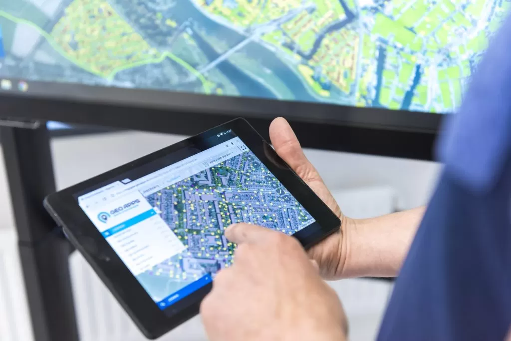
As a housing corporation, you want to stay in control of your property portfolio. With the right tools, maintenance and sustainability can be planned effectively, while giving you insight into tasks, projects, and their impact on residents. GeoApps offers a user-friendly map-based platform specifically designed to help housing corporations manage their real estate. In this blog, we explain how GeoApps can take property management to the next level.

Visualize all your real estate at a glance

One of the biggest challenges for housing corporations is effectively managing large numbers of properties spread across different locations. With GeoApps, you can easily create a clear and detailed overview of all property assets. Whether it concerns rental prices, the type of property, or the current status of a building (for example rented, for sale, or scheduled for demolition), GeoApps provides clear insights into your entire housing portfolio.

Sustainability and energy savings

Sustainability is an important theme for housing corporations. Reducing CO₂ emissions, improving the energy efficiency of homes, and investing in renewable energy sources are all priorities. With GeoApps, it is easy to track the progress of sustainability projects. Visualize which properties already have solar panels, check the status of insulation projects, and monitor the energy labels of your buildings. This way, housing corporations keep a firm grip on sustainability goals and can make quick adjustments where necessary.

🖼️
Image not available
This image could not be loaded
🖼️
Image not available
This image could not be loaded

Projectmanagement: overzicht en monitoring

Woningcorporaties hebben te maken met diverse opgaven en projecten tegelijk. Of het nu gaat om nieuwbouw, renovatie of onderhoud, het is essentieel om overzicht te houden en de voortgang goed te monitoren. GeoApps biedt een krachtig dashboard waarmee de voortgang of opgaven en projecten op één plek te volgen zijn. In één oogopslag is te zien wat de status is van lopende initiatieven, welke deadlines er naderen, en waar eventuele knelpunten liggen. Dit maakt het eenvoudiger om beslissingen te nemen en ervoor te zorgen dat projecten op tijd en binnen budget worden afgerond.

Perceelinformatie: gedetailleerde inzichten

Een goed inzicht in perceelgegevens is essentieel voor vastgoedbeheer. In de kaartviewer is het erg eenvoudig kadastrale kaarten te bekijken. Of het nu gaat om eigendomsgegevens, perceelgrenzen, of andere relevante informatie, GeoApps biedt de details die nodig zijn om goed geïnformeerd beslissingen te nemen. Dit helpt niet alleen bij het beheer van de huidige vastgoedportefeuille, maar ook bij de planning van nieuwe projecten.

Locatie-informatie: bereikbaarheid en voorzieningen

De locatie van vastgoed heeft een directe impact op de waarde en aantrekkelijkheid van panden. GeoApps biedt de mogelijkheid om de bereikbaarheid van belangrijke voorzieningen, zoals ziekenhuizen, supermarkten, en scholen, te analyseren. Zo is niet alleen de huidige waarde van vastgoed beter in te schatten, maar ook om strategische beslissingen nemen over toekomstige investeringen.

Conclusie

Met GeoApps hebben woningcorporaties en adviesbureaus de tools in handen om vastgoedbeheer over alle opgaven te optimaliseren. Van gedetailleerde vastgoedinformatie en verduurzaming tot projectmanagement en perceelinzichten, alles is beschikbaar in één gebruiksvriendelijk platform.

Ontdek hoe GeoApps uw vastgoedbeheer kan verbeteren en hoe u met ruimtelijk inzicht betere besluiten kunt nemen: boek direct een demo!

View All PostsGet a Demo
Back to overview

Related Posts

You might also like

GIS platforms in the Netherlands: what is the difference and where does GeoApps fit?

GIS platforms in the Netherlands: what is the difference and where does GeoApps fit?

A GIS platform is more than a map viewer. It supports organisation-wide spatial analysis, data-driven decision-making and communication using GIS and geospatial data.

January 14, 2026Read more
From Rigid to Smart GIS: Why More Organizations Are Switching to QGIS + GeoApps

From Rigid to Smart GIS: Why More Organizations Are Switching to QGIS + GeoApps

Many GIS environments are still stuck in old structures. High license costs, slow updates, and limited collaboration slow down innovation. Discover how organizations are moving to an open, flexible, and future-ready WebGIS with QGIS + GeoApps.

October 17, 2025Read more
How to Create Clarity in a Region Full of Sustainable Initiatives

How to Create Clarity in a Region Full of Sustainable Initiatives

Municipalities and regions are dealing with countless sustainability initiatives. GeoApps helps bring data together and make it transparent so that policies and collaboration are better supported.

September 30, 2025Read more

Ready to Get Started?

Join thousands of users who are already using GeoApps to transform their spatial data workflows.

Get a Demo
GeoApps Viewer
Gasfabriek project
MapGear team office
Last Updated: April 29, 2026