ExploreJobsAbout usContact
Log in
MapGear Logo
JobsNewsAbout MapGear
Log inContact
MapGear, known through GeoAppsGeoApps

Cookie settings

We use cookies to improve your experience on our website. You can choose which types of cookies you accept. Learn more

GeoApps Logo
Apps
Solutions
Platform
About us
Get advice
GeoApps Logo

GeoApps is the leading software platform for GIS applications and spatial data, enabling organizations to make data-driven decisions.

Solutions

  • Urban Planning
  • Infrastructure
  • Real Estate
  • Environment & Climate
  • Energy Transition
  • Safety & Risk

Products

  • GeoApps
  • Solutions
  • Sustainability Map
  • MapServices
  • TouchTable
  • Consultation

Apps

  • Viewer
  • Dashboard
  • Fieldwork
  • MapTour
  • MapTalk
  • Custom

For whom?

  • Municipalities
  • Provinces
  • Environmental Services
  • Engineering
  • Contractors
  • Safety Regions

Platform

  • Integrations
  • Documentation
  • System Status
  • Changelog
  • Support
  • Subscriptions

Company

  • About Us
  • Careers
  • Contact
  • Partners
  • News & Blog
  • Events

Stay up-to-date

Subscribe to our newsletter to get the latest updates on our products and services. You can unsubscribe at any time.

Keep an eye on our socials too

Stay connected with us through our social media channels and get the latest updates on our products and services.

Quality & trust

MapGear is ISO 9001 and ISO 27001 certified and meets the highest quality and security standards for our products and services.

ISO 9001 Certificering
ISO 27001 Certificering
QGIS Membership 2026
© 2026 MapGear B.V. All rights reserved.
Terms & conditionsPrivacy PolicySustainability statement
From Rigid to Smart GIS with QGIS + GeoApps | GeoApps Blog
From Rigid to Smart GIS: Why More Organizations Are Switching to QGIS + GeoApps hero background

From Rigid to Smart GIS: Why More Organizations Are Switching to QGIS + GeoApps

Many GIS environments are still stuck in old structures. High license costs, slow updates, and limited collaboration slow down innovation. Discover how organizations are moving to an open, flexible, and future-ready WebGIS with QGIS + GeoApps.

GeoApps Team• October 17, 2025News

From Closed to Open GIS

More and more Dutch organizations are choosing QGIS + GeoApps. Not because they have to, but because open and connected WebGIS simply works better.

Closed desktop GIS is being replaced by a modern web-based environment where data is accessible to everyone who works with it. This means less management, faster collaboration, and more room for innovation.


Old Structures Hold Back Progress

Many GIS environments are still too rigid. They are tied to license models, slow updates, and data that remains locked to a single workstation. As a result, innovation slows down and collaboration comes to a halt.

Teams spend more time on maintenance than on data. And every new opportunity runs into technical limitations.

“When your GIS is too rigid, progress stops.”


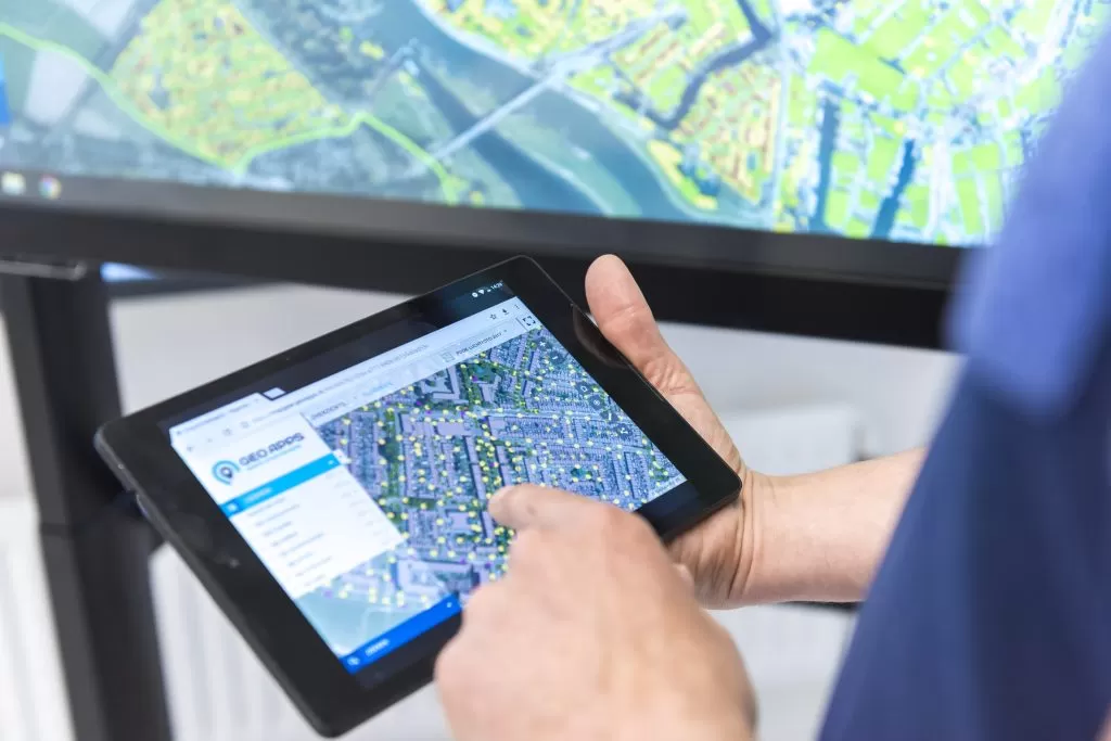
Freedom with QGIS + GeoApps

With QGIS + GeoApps, you have the freedom to build your own WebGIS. It is an open, connected, and scalable solution developed in the Netherlands and trusted by engineering firms that are modernizing their GIS strategy.

QGIS provides the power of open-source desktop GIS. GeoApps connects this power to a user-friendly WebGIS environment that allows organizations to share maps, data, and workflows in one clear platform.


Ready for the Future

Switching to open GIS is not only a technological decision but also a strategic step toward more collaboration, innovation, and autonomy.

Get your GIS ready for the future.

View All PostsGet a Demo
Back to overview

Related Posts

You might also like

GIS platforms in the Netherlands: what is the difference and where does GeoApps fit?

GIS platforms in the Netherlands: what is the difference and where does GeoApps fit?

A GIS platform is more than a map viewer. It supports organisation-wide spatial analysis, data-driven decision-making and communication using GIS and geospatial data.

January 14, 2026Read more
How to Create Clarity in a Region Full of Sustainable Initiatives

How to Create Clarity in a Region Full of Sustainable Initiatives

Municipalities and regions are dealing with countless sustainability initiatives. GeoApps helps bring data together and make it transparent so that policies and collaboration are better supported.

September 30, 2025Read more
How Online Maps Help Ecological Consultancy Flourish

How Online Maps Help Ecological Consultancy Flourish

Digital maps make ecological consultancy work more efficient and transparent. Discover how GeoApps supports organizations in nature research, public participation, and policy development.

September 30, 2025Read more

Ready to Get Started?

Join thousands of users who are already using GeoApps to transform their spatial data workflows.

Get a Demo
GeoApps Viewer
Gasfabriek project
MapGear team office
Last Updated: April 29, 2026