Engineering firm Stantec brings all area information together in one secure online portal. Potential buyers of plots gain direct access to up-to-date documents, while the sales team keeps full control over who can view which information.
In area development and plot sales, a lot of documentation is involved — from asbestos declarations to soil reports. Engineering firm Stantec consolidates all this information in one clear Area Information Management (GIM) portal.
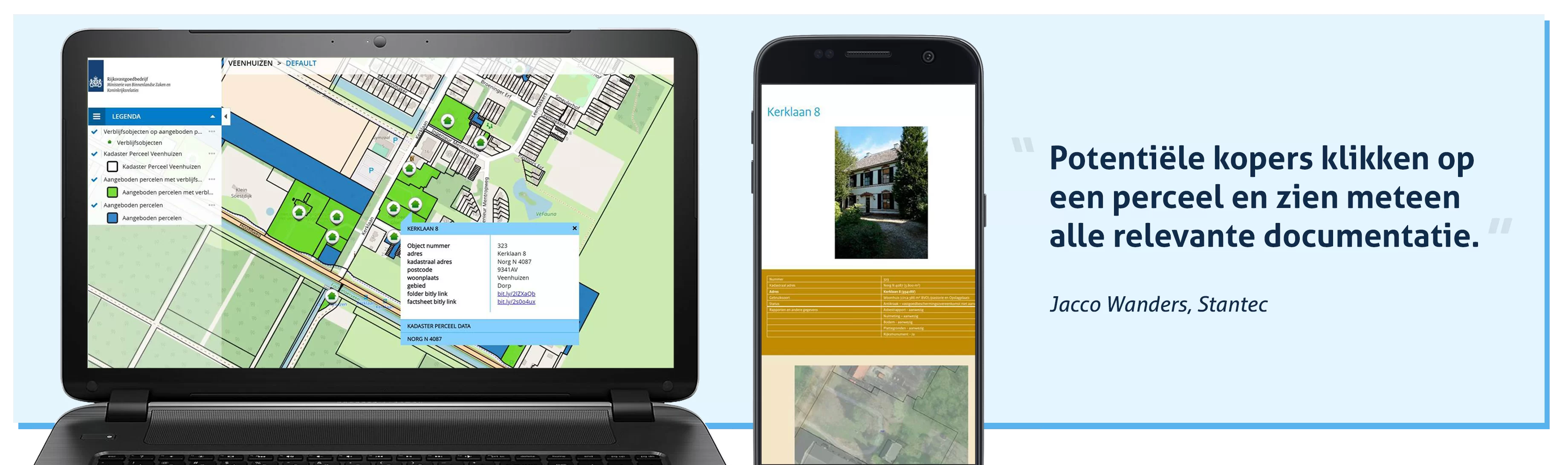
Potential buyers click on a plot via a digital map and immediately see all relevant documentation.
“Documents are always up to date thanks to the integration with SharePoint. The sales team decides who gets access and which documents are visible,” explains Jacco Wanders, GIS Consultant at Stantec.
At present, Stantec manages the GIM portal for the Central Government Real Estate Agency (Rijksvastgoedbedrijf) to support the redevelopment of cultural heritage in the Drenthe village of Veenhuizen.
The area covers about 1,350 hectares of real estate, woodland, heathland, farmland, and infrastructure.
Veenhuizen has had a judicial function since the 19th century and remains state property. Although two prisons still operate there, other state-owned land and buildings are being divested.
Through the GIM portal, these properties are mapped and documented to support sustainable redevelopment while preserving cultural and historical value.
Area information management involves many information flows. A key goal of the GIM portal is to centralize all relevant data.
“We assist in setting up and maintaining the portal. After that, maps and reports are available 24/7. This allows potential buyers to make well-informed assessments,” says Jacco.
When it comes to sharing information externally, current digital workspaces of many organizations are often limited.
“Files can be too large or not shareable online due to security reasons. That’s why we created a SharePoint integration for the sales team at the Rijksvastgoedbedrijf,” Jacco explains.
“This Microsoft platform enables the team to exchange and collaborate on information online in a secure way.”
The SharePoint integration connects the documents from the online workspace of the Rijksvastgoedbedrijf directly to the GIM platform.
When interested parties view a plot’s factsheet or report, they automatically see the latest version.
Project staff can supplement or update documents without having to relink them each time — saving both time and effort.
“With this GIM platform, we help clients organize their sales process efficiently and securely,” says Jacco.
“The Rijksvastgoedbedrijf sales team can add and validate information themselves and decide who has access. They can also define which information users may view — for example, whether certain factsheets are view-only or downloadable.”
Stantec now successfully uses the GIM portal in two additional redevelopment projects:
The Hembrug industrial heritage site in Zaandam and Vliegkamp Valkenburg near Katwijk.
“The use of GeoApps as an intuitive map viewer has proven its value in these projects. Navigation in the viewer is self-explanatory thanks to its clear and simple interface,” says Jacco.
“Users need little to no training. Once the portal is configured, it practically runs itself. That makes it an ideal tool for managing area development projects.”
For more information about the portal, contact info@geoapps.nl.
Let's discuss your use case.
Let's discuss how GeoApps can help bring your vision to life