Skip to main contentSkip to navigation
ExploreJobsAbout usContact
Log in
MapGear Logo
JobsNewsAbout MapGear
Log inContact
MapGear, known through GeoAppsGeoApps
GeoApps Logo
Apps
Solutions
Platform
About us
Get advice
GeoApps Logo

GeoApps is the leading software platform for GIS applications and spatial data, enabling organizations to make data-driven decisions.

Solutions

  • Urban Planning
  • Infrastructure
  • Real Estate
  • Environment & Climate
  • Energy Transition
  • Safety & Risk

Products

  • GeoApps
  • Solutions
  • ESG-Maps
  • MapServices
  • TouchTable
  • Consultation

Apps

  • Viewer
  • Dashboard
  • Fieldwork
  • MapTour
  • MapTalk
  • Custom

For whom?

  • Municipalities
  • Provinces
  • Environmental Services
  • Engineering
  • Contractors
  • Safety Regions

Platform

  • Integrations
  • Documentation
  • GIS Lexicon
  • System Status
  • Changelog
  • Support
  • Subscriptions

Company

  • About Us
  • Careers
  • Contact
  • Partners
  • News & Blog
  • Events

Stay up-to-date

Subscribe to our newsletter to get the latest updates on our products and services. You can unsubscribe at any time.

Keep an eye on our socials too

Stay connected with us through our social media channels and get the latest updates on our products and services.

Quality & trust

MapGear is ISO 9001 and ISO 27001 certified and meets the highest quality and security standards for our products and services.

ISO 9001 Certificering
ISO 27001 Certificering
QGIS Membership 2026
© 2026 MapGear B.V. All rights reserved.
Terms & conditionsPrivacy PolicySustainability statement
Project hero background
Back to Project Overview
Icon
Dashboard
Icon
Custom Apps
Case-study

700.000 zonnepanelen gedetecteerd voor RESU16

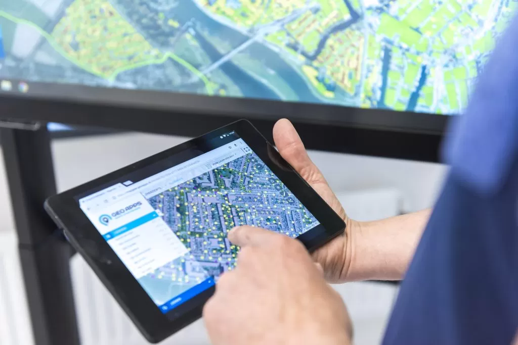
In opdracht van RESU16 zijn meer dan 700.000 zonnepanelen geïdentificeerd in de regio Utrecht. GeoApps en het team van geo-operators hebben actuele luchtfoto’s gebruikt om zowel bestaande installaties als toekomstig potentieel inzichtelijk te maken.

Client:RESU16 / regio Utrecht
Published:September 30, 2025
700.000 zonnepanelen gedetecteerd voor RESU16

Voor #RESU16 (Regionale Energie Strategie regio Utrecht) hebben we ruim 700.000 #zonnepanelen in kaart gebracht! Van 16 gemeenten is nu precies bekend waar al zonnepanelen geïnstalleerd zijn én waar de potentie voor extra panelen nog groot is. Met Duurzaamheidskaart Pro is in kaart gebracht in welke wijken nog veel potentie is en op welk soort gebouwen (bv. woningen, kantoren, scholen, buurthuizen etc.). Deze statistieken worden door RESU16 gebruikt als cijfermatige onderbouwing voor het regionale beleid rondom zonne-energie.

Ons team van geo-operators heeft in een periode van ruim twee maanden alle zonnepanelen visueel gedetecteerd vanaf actuele luchtfoto’s. Een flinke klus, maar alles voor de beste kwaliteit data!

Handmatig VS AI/Machine learning
Want een automatisch algoritme detecteert misschien sneller, maar deze techniek is erg kostbaar en vaak ook minder accuraat. Door kleurverschillen en schaduwen op luchtfoto’s blijken zonnepanelen door algoritmes soms lastig te onderscheiden. Terwijl een getrainde operator meestal snel herkent of het gaat om een PV-installatie of iets dat erop lijkt, zoals een carport of kassencomplex.

Zicht op toename PV-installaties 
Onze kaartapplicatie #GeoApps is als basis gebruikt voor het accuraat detecteren en invoeren van zonnepaneel installaties, zodat deze data nu ook als geografisch bestand beschikbaar is. De ingebouwde analysetool maakt bovendien een nauwkeurige prognose van het aantal zonnepanelen over bijv. 5 of 10 jaar. Zo krijgen #RESU16 en de Utrechtse gemeenten beter inzicht in de verwachte toename van het aantal PV-installaties in de komende jaren.

Volgende project wordt nog groter! 
Onze innovatieve werkwijze is zeker niet onopgemerkt gebleven. Inmiddels mogen we ook aan de slag voor Provincie Limburg! Om het aantal zonnepanelen te detecteren in dit gebied van 2.209 km² werken we samen met een extern team van professionele geo-operators van #Bee4GIS, zodat we de resultaten al binnen enkele weken kunnen opleveren!


🖼️
Image not available
This image could not be loaded
🖼️
Image not available
This image could not be loaded
🖼️
Image not available
This image could not be loaded
🖼️
Image not available
This image could not be loaded

Gerelateerde berichten

  • Een nieuw tijdperk voor historische collecties… Tijdreis Overijssel

  • Nieuwe softwarekoppeling maakt archeologisch veldwerk future-proof

  • Race tegen de rupsen: Roelofs bestrijdt eikenprocessierups middels kaart

  • De energietransitie op bedrijventerreinen versnellen? Nieuw platform in aantocht!

  • MapTour: kaartprojecten

Ready to start your own project?

Let's discuss how GeoApps can help bring your vision to life

Get a Demo Contact Us
GeoApps Viewer
Gasfabriek project
MapGear team office

Does your organization need a similar approach?

Let's discuss your use case.

Book a demoBack to all case studies
700.000 zonnepanelen gedetecteerd voor RESU16 | Case Study | GeoApps