How Data-Driven Green Planning Helps Cities Become More Resilient
Cities need clearer insight into green space, heat stress, biodiversity and climate risks. Discover how spatial data helps turn urban greening ambitions into measurable priorities and better-informed investments.
Turning Urban Green Data into Smarter Climate Decisions
Cities are under increasing pressure to become greener, healthier and more climate resilient. Urban populations continue to grow, public space is limited and challenges such as heat stress, biodiversity loss, water management and declining liveability increasingly compete for attention and investment. At the same time, residents expect greener neighbourhoods, healthier public spaces and visible climate adaptation measures, while municipalities and urban planners must decide where interventions are most urgently needed and which investments are likely to create the greatest long-term value.
This creates an important challenge: how can urban green policy move from broad ambition to measurable, defensible and location-specific action? Spatial data provides an increasingly important part of the answer by helping cities understand where green infrastructure is lacking, which areas are vulnerable and where interventions can deliver multiple benefits.
Green Infrastructure Is Becoming Essential Urban Infrastructure
Urban green is no longer simply an aesthetic element of city planning. Trees, parks, green corridors and other forms of vegetation can contribute to cooling, biodiversity, water retention, air quality and healthier living environments. As climate pressures increase, these functions become increasingly important to the way cities plan and manage public space.
This means municipalities need more than general targets for adding trees or increasing green coverage. They need spatial insight into where green is currently available, where vulnerable areas are located and how different neighbourhoods compare. A comprehensive green analysis can bring together indicators such as:
existing green coverage
tree quality and distribution
green space available to residents
shade and heat exposure
biodiversity indicators
water retention opportunities
planned spatial developments
By analysing these factors together, cities can build a more complete picture of how urban green contributes to resilience and where additional intervention may be needed.
Make Green Priorities Easier to Identify
One of the biggest challenges in urban greening is deciding where limited budgets and available space should be used first. Without spatial insight, investments can become fragmented across individual projects rather than guided by a broader understanding of need and potential impact.
Location-based analysis helps cities compare neighbourhoods and identify patterns that might otherwise remain hidden. Teams can see where green accessibility is limited, where heat exposure is concentrated, where biodiversity could be strengthened and where additional vegetation could support several policy goals at the same time.
This makes it easier to identify:
neighbourhoods with limited access to green space
areas vulnerable to heat stress
gaps in tree coverage or canopy
opportunities to strengthen biodiversity
locations suitable for additional cooling or water retention
areas where green investments could deliver multiple benefits
Instead of treating each sustainability challenge separately, spatial analysis helps reveal where different priorities overlap and where coordinated interventions could create greater value.
Connect Climate Adaptation with Everyday Urban Planning
Climate adaptation becomes more effective when it is integrated into wider spatial planning rather than handled as a separate programme. Decisions about housing, mobility, redevelopment and public space can all affect the amount, quality and distribution of urban green.
By combining green indicators with other spatial datasets, planners can better understand how proposed developments could influence local climate resilience. This creates opportunities to identify potential problems earlier and incorporate green measures before plans become difficult or expensive to change.
The same spatial overview can also support collaboration between sustainability teams, planners, asset managers and decision-makers. When teams work from the same geographic context, priorities become easier to compare, explain and translate into coordinated action.
Move from One-Time Analysis to Continuous Monitoring
Urban environments continue to change after a green strategy has been adopted. New construction alters neighbourhood density, trees mature or disappear, climate risks evolve and new data becomes available. Resilient green planning therefore requires continuous monitoring rather than relying on a single assessment.
Spatial monitoring allows cities to follow developments over time and determine whether interventions are producing the intended results. This can involve tracking changes in green coverage, monitoring tree inventories, comparing neighbourhood indicators or reviewing progress against measurable objectives.
A more continuous approach can help cities:
identify emerging vulnerable areas
monitor changes in green coverage
follow biodiversity indicators
evaluate climate adaptation measures
compare progress between neighbourhoods
adjust investment priorities as conditions change
This turns green planning into an ongoing management process where new information can be used to refine priorities and improve future interventions.
Make Urban Green Decisions Easier to Explain
Municipalities increasingly need to justify why one neighbourhood, street or project receives priority over another. Clear spatial evidence can make these choices easier to communicate because the reasoning behind an intervention can be connected directly to measurable conditions at a specific location.
Maps and dashboards help decision-makers and stakeholders understand where challenges are concentrated and how proposed measures respond to them. This creates a stronger basis for internal decision-making, investment planning and communication with residents. Better transparency does not make every decision simple, but it does make priorities and trade-offs easier to understand and substantiate.
How ESG Maps Supports Data-Driven Green Planning
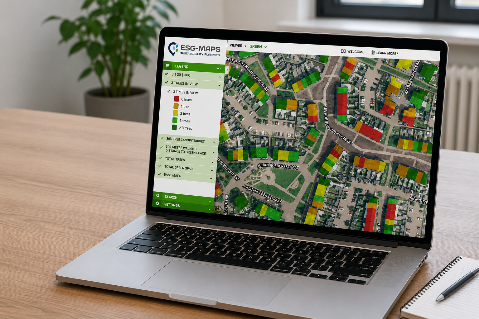
ESG Maps helps organisations combine spatial data, green indicators and sustainability information within one map-based environment. This makes it easier to analyse urban green at neighbourhood and city level, compare areas and identify where additional attention may be required.
With Green Insight, teams can bring together information related to green coverage, biodiversity, heat exposure and other relevant indicators. Instead of working with separate datasets and reports, planners can use one spatial overview to support analysis, prioritisation, monitoring and communication.
This helps organisations move from broad green ambitions toward clearer decisions about where intervention is most urgent, which areas could benefit most and how progress can be monitored over time.
From Green Ambition to Measurable Urban Resilience
Greener cities are not created by adding vegetation wherever space happens to be available. Effective urban greening requires a clear understanding of where green infrastructure is needed, which challenges it can help address and how investments contribute to wider climate and liveability objectives.
By combining spatial data with measurable green indicators, cities can make urban greening more strategic, transparent and responsive to changing conditions. This creates a stronger foundation for healthier neighbourhoods, greater climate resilience and better-informed long-term investment decisions.
Ready to Make Urban Green Priorities More Measurable?