“Berekeningen waarvoor we vroeger een week nodig hadden, zijn nu in enkele minuten klaar. Dat bespaart ons enorm veel tijd én geld.”
Potentiel solaire & politique
Une source de données, deux usages : une Carte solaire accessible pour les habitants et Carte solaire Pro pour la politique, le reporting et le suivi RES.
L'énergie solaire est la forme de production d'électricité la moins chère et la plus propre. La visibilité sur le potentiel solaire aide municipalités et habitants à accélérer la transition énergétique. De la sensibilisation à la politique : une source de données pour la carte publique et l'analyse professionnelle.
Production
Potentiel de toit cartographié
Politique
RES & reporting
Habitants
Carte publique
En tant que municipalité ou autorité publique, vous souhaitez orienter la politique sur l'énergie solaire et rendre compte. Des chiffres incertains, des retards de reporting et la résistance des habitants compliquent cette tâche.
Vous peinez à obtenir des chiffres actuels sur la capacité installée et la progression. Sans données fiables, le pilotage de la réalisation et des objectifs RES stagne.
La résistance et le manque d'information claire retardent les projets. Une carte solaire accessible aide les habitants et réduit les questions inutiles au guichet.
Le conseil et l'administration veulent des chiffres actuels ; province et gouvernement national demandent des justifications. Sans données cohérentes, le reporting est difficile.
“Pour atteindre les objectifs climatiques, environ 5 GWp de nouvelle capacité solaire sont nécessaires chaque année ; en 2024, environ 3,4 GWp ont été installés.”
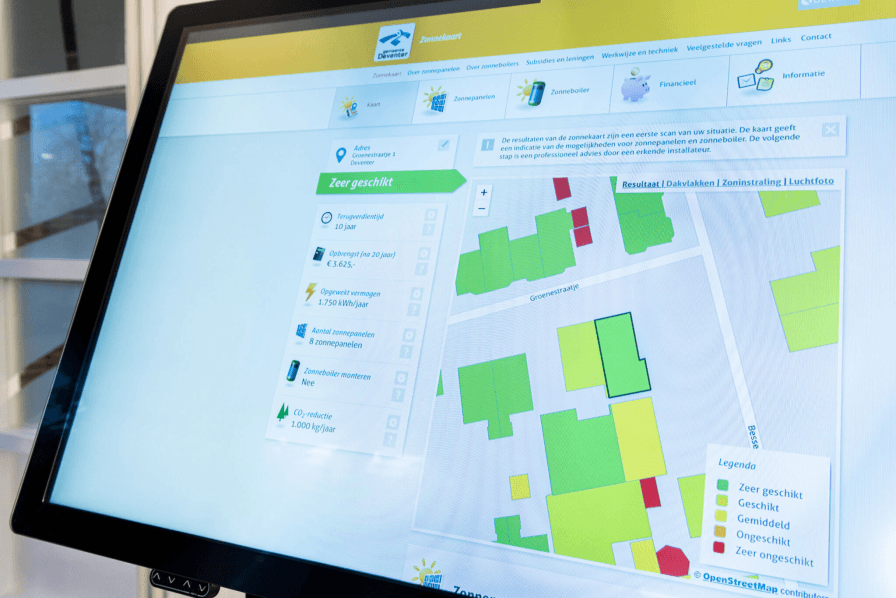
Une carte : potentiel de toit, capacité installée et progression par quartier ou district. Pour piloter la réalisation, le reporting RES et les choix politiques.
Utilisez les mêmes données actuelles pour la communication publique et l'analyse professionnelle. Les habitants voient ce que leur toit peut produire ; les décideurs pilotent progression, potentiel et reporting.
Voir les optionsLe solaire est disponible sous forme de Carte solaire pour les habitants et Carte solaire Pro pour la politique et la prise de décision. Chacune a sa place ; elles servent des objectifs différents.
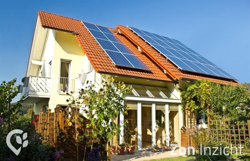
Une carte solaire accessible permettant aux habitants de voir si leur toit convient aux panneaux solaires et quel est le rendement estimé. Idéal pour informer les habitants.
Pour décideurs et autorités publiques : détections de panneaux solaires, moniteur solaire, tableaux de bord et rapports. Suivi RES, export et connexion à votre propre GIS ou portail.
Le solaire repose sur des données actuelles et un moniteur solaire fiable. Cela vous donne une visibilité sur la capacité installée, le potentiel de toit et la progression.
Nous organisons la détection de panneaux sur les toits à partir d'images aériennes actuelles, en combinant contrôle manuel et IA.
Le moniteur solaire cartographie capacité installée, potentiel de toit et progression par zone.
Une boîte à outils complète pour les municipalités qui prennent au sérieux le solaire. De la politique à la pratique : des résultats mesurables pour une transition énergétique durable.
Analyse détaillée du potentiel solaire sur tous les toits de votre municipalité.
Calcul précis du rendement énergétique attendu et des retours financiers.
Sélection intelligente de sites pour projets solaires basée sur les données.
Outils pour communiquer efficacement avec les habitants sur l'énergie solaire.
Page actuelle
Insight Solaire est intégré de manière transparente à la plateforme DZHK, avec toutes vos autres données de durabilité pour une vue d'ensemble complète de la transition énergétique.
Énergie solaire
Expériences d’organisations qui travaillent avec DZHK.
“Berekeningen waarvoor we vroeger een week nodig hadden, zijn nu in enkele minuten klaar. Dat bespaart ons enorm veel tijd én geld.”

“We presenteren onze expertise niet meer als saaie rapporten, maar als interactieve kaartapplicaties. Zelfs mensen zonder technische kennis kunnen er gebruik van maken, wat Duurzaamheidskaart tot een essentiële basis maakt voor beleidsvorming.”

“Duurzaamheidskaart heeft ons geholpen om duurzaamheidsdata toegankelijk te maken voor iedereen. Het platform combineert krachtige visualisatie met eenvoudige gebruikerservaring.”
“Samen met MapGear (Duurzaamheidskaart) konden we een realistische prognose maken van de zonnepotentie in Groningen in 2035. We combineren data over daken, warmtepompen, elektrisch rijden en beleidskeuzes voor een betrouwbaar toekomstbeeld.”
“Samen met MapGear (Duurzaamheidskaart) ontwikkelden we de TransitiePlanner. Deze stelt ons in staat data te verzamelen, analyseren en visualiseren over energieverbruik, klimaatadaptatie en duurzame mobiliteit. We bouwen een dynamisch dossier op voor duurzame bedrijventerreinen.”

“De duurzaamheidskaart heeft ons geholpen om onze energietransitieprojecten efficiënter te plannen en uit te voeren.”

“Met Asbestdakenkaart hebben we voor het eerst overzicht op onze asbestdata en saneringsvoortgang. Eén plek om te prioriteren, monitoren en rapporteren.”
“Berekeningen waarvoor we vroeger een week nodig hadden, zijn nu in enkele minuten klaar. Dat bespaart ons enorm veel tijd én geld.”
“We presenteren onze expertise niet meer als saaie rapporten, maar als interactieve kaartapplicaties. Zelfs mensen zonder technische kennis kunnen er gebruik van maken, wat Duurzaamheidskaart tot een essentiële basis maakt voor beleidsvorming.”
“Duurzaamheidskaart heeft ons geholpen om duurzaamheidsdata toegankelijk te maken voor iedereen. Het platform combineert krachtige visualisatie met eenvoudige gebruikerservaring.”
“Samen met MapGear (Duurzaamheidskaart) konden we een realistische prognose maken van de zonnepotentie in Groningen in 2035. We combineren data over daken, warmtepompen, elektrisch rijden en beleidskeuzes voor een betrouwbaar toekomstbeeld.”
“Samen met MapGear (Duurzaamheidskaart) ontwikkelden we de TransitiePlanner. Deze stelt ons in staat data te verzamelen, analyseren en visualiseren over energieverbruik, klimaatadaptatie en duurzame mobiliteit. We bouwen een dynamisch dossier op voor duurzame bedrijventerreinen.”
“De duurzaamheidskaart heeft ons geholpen om onze energietransitieprojecten efficiënter te plannen en uit te voeren.”
“Met Asbestdakenkaart hebben we voor het eerst overzicht op onze asbestdata en saneringsvoortgang. Eén plek om te prioriteren, monitoren en rapporteren.”
Demandez une démo pour le suivi solaire, le reporting RES et les détections de panneaux.
Réponses sur Solaire, Carte solaire et Carte solaire Pro.
La confiance des communes, provinces et organisations aux Pays-Bas et en Belgique


Vous voulez savoir ce que nous pouvons faire pour votre organisation ? Contactez-nous pour une démo sans engagement. Besoins particuliers ? Laissez vos coordonnées ci-dessous.